|
 |
Friday
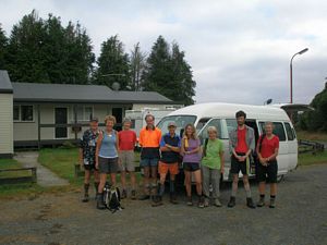
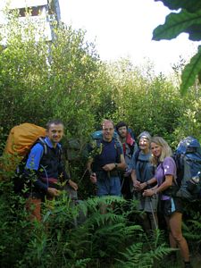
11 km. A very hot, sunny day. After a night spent in a pleasant cabin at the Pureora
Field Centre we all set off at 8.25 am in the minibus via the Link Road and Western Bays Road to Waihora
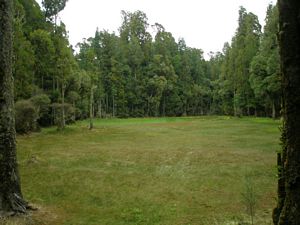
Lagoon carpark. We all walked down the very well formed track to look at the Lagoon, looking out for
and discovering a Geocache on the way. Due to the long dry period the Lagoon was dry enough to walk on
and sported a good coat of green grass.
|
|
|
|
|
Here, at 10 am, the two groups parted, the daywalkers to drive to the Waihaha carpark and to
walk up to the Waihaha hut and back, the pack-carry group to walk up the Waihora track to join the Hauhungaroa
Track. The track initially followed an old four-wheel drive track which gently climbed for 1.5 hours
up to the ridge, crossing a pretty stream shortly before reaching the junction, which we discovered was
actually not where indicated on the Topo map – it was approximately half a kilometre further south, luckily
in the direction we intended to go.
We continued southwards along this very well marked and easy
track enjoying the beautiful weather and lovely bush, with a stop for lunch and our devotion at 12.30
pm. Eventually we came to the Mangatu Stream which entailed a very steep 140m scramble down, wading
the river, crawling under a fallen tree, and then a very long 140m climb up again.
After another
1.5 kilometres we were very pleased to reach the 10 bunk Waihaha hut at 4 pm. Due to its heavy use the
water tank was dry but we were able to fill the billies from the nearby stream for a much needed mug
of tea. Many hunters use the hut and the grassy area around the hut was littered with bones and evidence
of dogs – and by the end of the afternoon there were seven others and four dogs on site, so four of us
put up tents outside. We all had quick refreshing dips in the very cold Waihaha River, and spotted a
couple of blue ducks, before our evening meal and an early night.
Saturday
16 km. (The
signboard at Waihaha hut is incorrect at 12km) Another sunny, hot day. We set off at 8.15 am, following
the Waihaha River southwards. Although the signboard had indicated 3 km to the Te Awaiti Stream, our
GPS showed that, in a straight line, it was at least 4.5 kilometres – and the path was certainly not
straight! So it was not surprising that it took two hours to reach this last stream before we began climbing
up the ridge. We had been told by a very friendly hunter that the only available water at the new Hauhungaroa
Hut was from the tank collecting rain from the roof. After our experience at the Waihaha Hut we decided
to fill as many containers as possible at the stream and David Korff and David Titheridge kindly carried
most of it up and up for the rest of the day. We also commented that, although the route was very well
marked, it was obviously not very frequently walked and the trees seemed determined to make difficulties
for us as many had sacrificed themselves by falling down across our path! However we won through and
eventually enjoyed a long lunch and devotions at 12.30 pm almost at the top of the ridge.
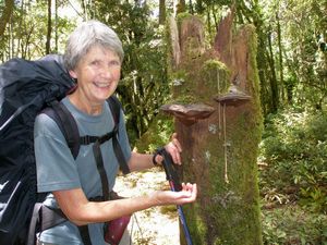
Val
jokingly suggested that we try to find her sunglasses which she had left hanging on a tree stump by their
cord beside the spot where a Club group had camped when tramping this track in the reverse direction
in January 2002! The camping spot was found and there, hanging on a stump was the safety cord, now faded
and caught firmly by a bracket fungus which had grown around it. The glasses had gone – we wondered
whether there was a cool-dude possum somewhere in the bush!
|
|
 |
We continued along the ridge, getting the occasional glimpse southwards to Ngauruhoe and Ruapehu,
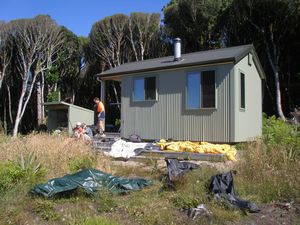
until at 3.45 pm we reached the site of the new hut (956 m.) Many trees had been cut to provide space
on the northern side of the ridge, and to provide wonderful views north and north-westwards towards Pirongia.
The six-bunk hut, which we had to ourselves, was great, very clean, light and reasonably spacious, although
getting water from or washing-up in the outside sink would have been a very cold and wet experience in
bad weather. The hut book indicated that the hut had not been heavily used and the water tank was full
so we did not need to stint ourselves.
|
|
 |
Sunday
7 + 2 km. We left the hut in a slight mist at 8.30 am and followed the fairly level
ridge westwards, and soon reached the old trig point on the top of Motere (approx. 990 m), now nearly
enveloped in vegetation. The mist had cleared and once again we were glad of the shade of the bush. From
the trig the path began to descend, in one place very steeply, until eventually it emerged from the bush
and followed a four-wheel drive track to the original road end. The road is now in such a bad condition
that radio contact with David Kilgour confirmed that they had parked the minibus a further two kilometres
back along the Mangakahu Road. We joined the day walkers and arrived at the minibus at 11.30 am after
having enjoyed a wonderful weekend’s tramp.
|
|
 |
COSTS:
Minibus $43.20
Diesel Fuel $10.00
Cabin $12.00 or $36.00 for day walkers
Huts
$10.00 or nil if Annual Hut Pass holder
Food $14.00 or $20.00 for day walkers
Levy $5.00
or nil for day walkers
Admin $1.00
Total $95.20 or $110.20 for day walkers per person
|
|
|