Well this was the second go to get this trip off the ground. This was to an area were the club had not
been before.
Leader Alasdair had the information on the Komata Reefs for a while ( Reference Book
– Coromandel Gold by Phil Moore and Neville Richie) in it was an interesting article and a map of the
Goldfield.
Not having done a reecy to the area prior to the trip it was going to be an interesting
day. During the week prior to the tramp Alasdair found that the Manukau Tramping Club had done the trip
back in January however their report of their adventure didn’t give me a lot of confidence that we would
achieve what we intended to do as they mentioned that parts of the tram track was overgrown and there
was very few route markers.
However a google of the internet turned up a webpage of a local who
had done a lot of tramping area and had GPS coordinates of some of the key points of interest in the
area noted and seeing that he felt the day tramp would no longer be a problem.
Well top marks
must go to the 12 participants for managing to arrive at the meeting place at Komata Reefs Road by the
suggested meeting time of 9.15am.
Left the cars at 9.45 am and headed along the track and past
an old hut which was hanging partly over the stream bank having been undermined at some stage from a
flooded stream.
Just beyond here we came to the first decision point at a place where the track
forked just beyond the No. 5 level of the mine, which had been signposted.
At this point it was
decided to follow up the stream, with the GPS set to co-ordinates for the boiler at the mines No 1 level
at the head of the stream approx 400 metres away (2754444 E and 6424453 N).
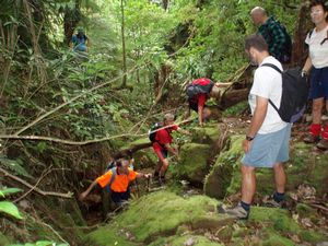
The stream was now
confined to a narrow ravine full of mine tailings, green slippery rocks, and occasionally some small
vertical climbs.
It took us about one and a quarter hours to travel this section of stream, past
the number 3, 2 and 1 levels each with their mine entrances and rusting mine equipment, finally arriving
at the hopper level where the remains of the boiler was, along with the main vertical mine shaft which
serviced all the levels below. Here we had lunch.
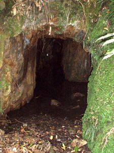
From there we set off south along the tramway
to the tunnel (2754422 E and 6424222 N). It was good to have this reference as the track was not well
defined as we approached the tunnel and the track junction was not obvious so we depended on the GPS
to get to the right location.
Once through the tunnel it was then all down hill back to the cars
arriving at 1.45 pm.
Everyone enjoyed there day of off track tramping and appreciated the value
of navigation by GPS.
|
|