
|
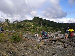
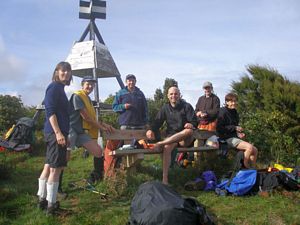
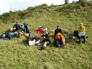
Saturday On Saturday morning seven of us, having met at 7.30 at Bracken Avenue, travelled down to the carpark at the southerly end of Otau Road in the Wairoa Valley in the Hunua Ranges. Here we were joined by the Masters family who planned to do a day walk. Our son also met us in order to move the vehicle, plus trailer, around to the end of our tramp at the Waharau Regional Park. We set off up the Wairoa Loop Track soon after 9 am and made good time as we climbed steadily for 2.6 km to Repeater Road. We all made our way to the lookout and stopped for a break and Bev’s devotion as we enjoyed good views eastward over the Upper Mangatawhiri Reservoir. The Masters family decided to make their own way from here so we continued southwards, over the Moumoukau Road and joined the Lower Mangatawhiri Track which follows the undulating ridge southwards. Very soon it became obvious that the actual walking path was rarely used so we, as had been obviously done by others before us, stepped over the wire fence and walked along the exotic forest track which ran parallel with the border of the forest. Where areas had been felled we gained good westward views and at noon were glad to stop for lunch in the sunshine in a high open area. We continued for another 1.5 km before turning back into the bush and making our way down the steep path into the Moumoukai Valley where we waded across the Mangatawhiri river and arrived at the Lower Mangatawhiri Campsite at 2.00pm, having travelled the total 10.5 km much faster than anticipated due to using the forest track instead of the much overgrown footpath. It was a very pleasant large open site beside the river and we soon set up the two Trios tents, plus two one-man tents owned by our new members Peter K. and Andre, and then enjoyed a good cup of tea. As the sun set soon after 5 pm we lost no time in organising our evening meal before dark and by 7 pm were crawling into our sleeping bags. Sunday Despite getting up in the dark we were later leaving the site than planned, setting off at 8.40am, knowing that we had a long hard day ahead. The first leg was up Mangatangi Trig Track to Mangatangi (487 m) which was quite a climb and we were glad to take a rest at the top and once again enjoy some lovely views. From the trig we dropped down to the Mangatangi Hill Road and marched swiftly down to the Mangatangi Reservoir where the water level was exceedingly low. Across the huge earth Dam - one of the largest in the Southern Hemisphere - is a very informative Visitors Information Centre so we spent a short time there before pressing on up Mt. Workman (428 m) and stopping for lunch just before re-entering the bush. Here David shared a devotion with us before we set off at 1.30pm northwards along the Workman Track which runs along a very undulating ridge. At first we encountered a lot of sticky yellow mud as we slipped down slopes and climbed up more slopes, but gradually the path underfoot improved. Nevertheless, it was slow going as we encountered fallen trees, the inevitable supplejack and many tree roots, and we began to get anxious about the possibility of not reaching the Workman campsite until after dark. Somehow the three ladies drew ahead of the four men and, with considerable relief, arrived just as the sun set at 5.15 pm. However, as darkness fell and the forecast showers fell they were concerned that the men would find the route difficult so were very pleased to see them arrive safe and sound at 6 pm. The site is only a smallish grassy glade in the bush but there is a (doorless) longdrop and an arrow pointing down to water (a stream). This was probably non-existent due to the previous dryness and the fact we were high on a ridge so a few days previously we had taken in and hidden 24 litres of water which we were very glad to have to hand. Never was an instant soup so much enjoyed as we prepared our well-earned supper, and congratulated ourselves on managing the quite difficult 16 km. in such good heart. We calculated that between the two campsites we had climbed a total of 1,089 metres and descended 689 metres, so no wonder we felt tired yet very pleased with ourselves at the end of the day. Monday Despite the intermittent showers we had a quiet night and were ready to leave the next morning by 9am. We soon came to the junction with the Whakatiwai Track and continued on a good path along the ridge for 2.6 km to join the Waharou Ridge Loop Track. Near this junction is a good viewpoint over the Firth of Thames towards the Coromandel and here we stopped for Val’s devotion in the sunshine before commencing the final 4 km down, down to the Visitor Centre in Waharau Park. We arrived at 12 noon and found our vehicle parked nearby. We then had our picnic lunch before driving back along the coast road, via Kawa Kawa and Clevedon, arriving at Bracken Avenue soon after 2 pm. COST: Campsites $10.00, Food $15.50, Equip Levy $3.00, Sundries $2.50, Transport $15.00 Total $46.00 |