|
"Grid lines, contour lines, landmarks, compass needle, direction of travel" … the language of an experienced
navigator after taking Val and Peter’s "Using Compass with Map" training at the beautiful Duder Regional
Park near Clevedon.
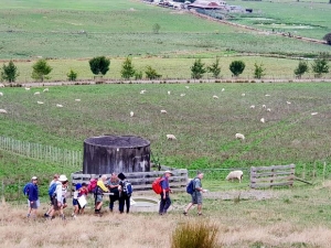
Sixteen club members, two guests and two children met at the park entrance
on Saturday 16 March 2019. After Murray began with a prayer which included our recognition of the tragedy
in Christchurch the previous day, Val introduced the detailed map of the park and helped us recognise
the orienteering markers and the topographical features shown on it. Our first challenge was to orientate
the map – then we set off to find our way to locate the first few markers – up the contours, along the
contours, turning at the cattle troughs and fence junctions and finding the gully or the ridge helped
us locate numbers 1, 13, 2, 14 then 3. Marker 4, labelled with a ‘T’ for tower, was obviously the trig
and we gathered for a congratulatory photo at reaching this spot so easily!!
Although some missed
the next marker (5) with the excuse that they were deep in conversation, we were soon ready to take out
our compasses and determine the direction to travel between two places on the map (the gate we had just
passed through and marker 16 - invisible over the brow of the hill!) Unfortunately, a new fence near
the edge of the cliff suggested marker 16 had been lost in land subsidence – but we all knew where it
should have been!!
Before we sat down for lunch under a giant old pohutukawa tree, Peter challenged
us to use our compass to follow the bearings North, East, South then West to pace out a square from a
fixed point (a milk bottle top) and get back to the same point!
After lunch we again set our
compasses onto the map to determine the grid bearing to our final marker (7) and were pleased that our
adjustments to avoid climbing the fence still pointed us to the correct point.
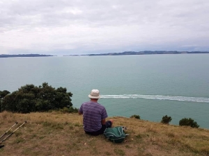
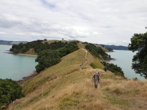
Our final walk
to Whakakaiwhara Point at the end of the peninsula (Pawhetau Pa site) provided even more spectacular
views of the coast and the islands of the gulf – what a wonderful place to spend a Saturday learning
how to safely navigate, enjoying and exploring a beautiful regional park and appreciating the grandeur
of God’s creation!
On the return to the car park, a small group of seven members who had the
ViewRanger app on their phone followed a Route ("Route for Duder Training") that they had previously
downloaded. As they walked across the fields, through the gates, along the beachfront and back to the
cars their phones not only showed them where to go but also recorded their journey and saved the details
for all to see.
Thanks Peter and Val for a very worthwhile and informative training day – we all
learned valuable skills and had a lot of fun together.
|
|
|
|
|
|