The tramp started at around 9:30am on a beautiful morning. 17 trampers in total, led by Mark Gibson and
Phillip and Ali Norton.
After we left the car park in front of the Anawhata Farm Gate near the
end of Anawhata Road, we quickly veered right and went along Kuataika track. It was a descending all
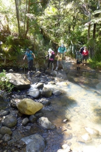
the way down the valley till we successfully crossed the Gentil Stream on our left. The walking then
began ascending all the way up past the Anawhata campsite on our left. We walked along for another 10mins
till we reached our second creek, the Kuataika Stream where the team paused by the creek on our right
and had a 10mins break for folks to have a drink of water or snack. There we veered left to continue
tramping keeping the creek on our right. This was where we began bush whacking, the team trailed through
thick bushes with good spirit. About 20mins later, we arrived near an old Maori Pa site. The first sign
was the big Boulder sitting in front of our eyes with the trickling sound of the waterfall in our ears.
We knew now the Pa site was close. This was also the joint of Kuataika Stream and Cannibal Creek (it
is well marked on the map Mark gave us at the beginning of the tramp). Here we veered right crossing
the Cannibal Creek and kept ascending for about 10mins, we came to the other side of the boulder on our
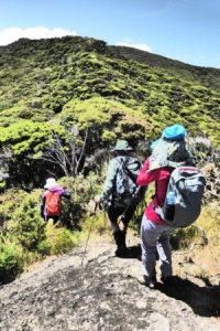
left. We climbed up zigzagging around the rock to a lush grass knoll. Walking through to the top, we
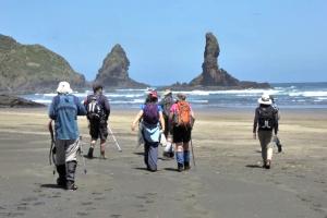
were rewarded with a stunning uninterrupted view of the lush green bush of the Waitakere ranges. Anawhata
beach stands in full sight now on our right. After about 10 mins photo session, we turned back to where
we came and sat on the grass knoll having our lunch break. It was a very pleasant place for lunch: well
shaded for a break away from the heat, manukau trees stretching their branches gracefully in front of
me as I ate my lunch. The team stayed for about an hour before we all headed back on the thin track through
dense bush. This time our aim was to get to the top of the ridge and find our way to Anawhata beach.
We crossed the Cannibal Creek again and bush-bashing with the creek on our right. Till we came to a place
where there was a small pile of the residue of a of wood-burning campfire on the ground, where the creek
is still close on our right, marking as an indicator according to our leaders to be the place where we
needed to make a sharp turn to the left and take the track on our left. A few steps up on our left from
the site of the campfire residue, we got on to a relatively defined track. About 10 minutes staying on
the track, we kept descending with the sound of the surf on the beach to our right, we came to the end
of that track to see the little rag (a white and blue handkerchief) tied to a branch of a low palm tree.
Here we made a sharp right turn to the little track down towards the beach. This was also a relatively
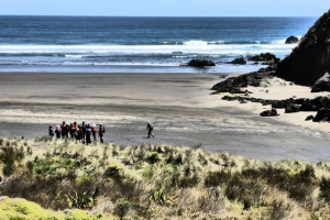
defined track. All the way down the track, we came to Anawhata beach. No one of the 17 trappers went
to the sea though some boasted they had brought their togs, we lingered on the beach for about 10 mins
to have all trappers down the track and get ready to head back up to the car park.
By this time,
the sun was well above us and the beach looked beautiful. We walked veer left and walked past another
Pa site (a big rock with a hollow front looking like a cathedral from the front) to the track upwards.
It took us about 20mins to get back up to a long driveway where folks stopped for have a drink of
water. Then we kept to our left and kept walking all the way up to the road where we veered right towards
our parking spot in front of the Anawhata Farm Gate on the left side of the road.
Though we had
different reports of the distance covered and the time used, they were close. So we will use a figure
that is close to the median of everyone's report: We used 3 hours 12 mins to cover the 11.12 kilometres
bush bashing and at times track tramping.
At 2:30pm, we were all back to the cars. And we thanked
our leaders Mark and Phil before we all got in our cars and headed home.
|
|
|
|
|