
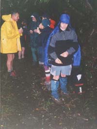
A drizzly day with no sunshine and no prospect of a view did not deter seventeen trampers from having
a go at a perennial Club favourite, the trip up the Wairongomai Valley in the Kaimai Ranges, continuing
up to the summit of Mt Te Aroha then directly down to the town of Te Aroha. The Club first did this trip
late in 1979, the year the Club was born, and had done this trip several times since.
We left
The Bracken soon after 8am and met up with some people at the Te Aroha Domain before carrying on to the
carpark at the start of the Wairongomai Valley just south of Te Aroha.
|
|
 |
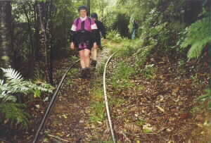
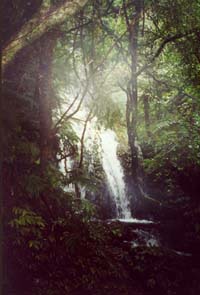
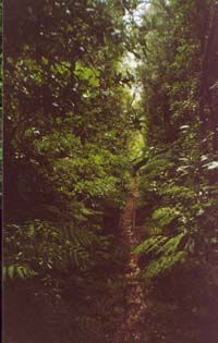
It was about 10:30 when we set out on our trip with our raincoats on, gradually climbing into the
bush along Bulldozer Track, the upper of the two main tracks into the Wairongomai Valley. There were
a few small but spectacular waterfalls, fuelled by the rain, where the track crossed streams in the hillside.
|
|
 |
Eventually we came to a footbridge over the Butlers Incline, the lower of the two steep winch-railways
forming part of the tramline that would bring out wagonloads of ore from the Wairongomai gold mines up
till 1955. The line is believed to have been built as far back as 1884 and was a 2ft gauge line that
went as far as Te Aroha. Looking down the incline from the bridge we could see some of the old railway
line.
|
|
 |
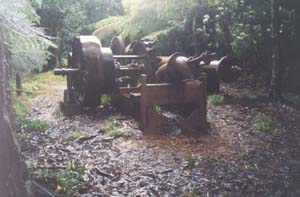
We had a brief morning tea stop about midday at the top of the Butlers Incline, where some of the
winch gear still stands, before carrying on along the old tramline. On previous trips we had taken the
Pack Track that climbed gradually to Hardy’s Hut - Grant, Cherry, Richard and Paul chose to take this
track while the rest of us followed the tramline, which had its rail tracks still intact.
|
|
|
|
|
The railway line eventually came to the foot of May Queen Incline, the second of the steep winch-railways.
These winch-railways, or inclines, would be used to winch the wagons of ore from the upper level railway
to the lower level railway where the locomotives would be waiting to take the wagons onwards.
About
a third of the way up the incline there was a track to the right to make the rest of the climb easier.
We had our lunch stop on the level railway line just beyond the top of the incline, standing up as it
was far too wet to take off our parkas and sit down. Grant and the others enjoyed the shelter of Hardy's
Hut.
|
|
 |
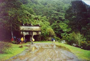
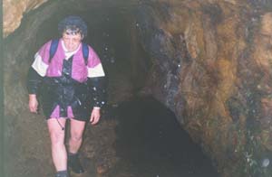
We passed the upper end of the Pack Track then dropped down to cross the Premier Creek then climb
up to go through a tunnel to the end of the line and another stream crossing.
|
|
 |
From there we had the long grunt up to the Mangakino Saddle and a more level walk to come out to
the Te Aroha Mountain Road (a private road built to service the TV transmitter on the summit) about half
an hour from the summit. We chose to take the road rather than the bush track to the top to save time,
as it was now very windy and exposed. We were glad to get out of the wind when we reached the shelter
of the transmitter building’s carport - one lady in the group was fortunate to be able to borrow a pair
of polyprop trousers as her trousers were wet right through and her legs were burning cold!
|
|
We were also glad to be back in the bush again out of the wind as we started to make our way down
the direct track to Te Aroha Domain. It was a steady downhill taking a bit over an hour, and we took
a quick stop at the Bald Spur lookout to get a view of the town of Te Aroha faded by the mist and drizzle.
We came out to Te Aroha Domain about 4:45pm, and welcomed a good soak in the hot pools nearby before
heading back to Auckland.
|
|
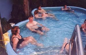 |
COST: travel $17; hot pools $4.
|
|
|