
This was a trip into areas where tracks were not marked and some skills in direction-finding were required.
The group of 16 who went had an interesting time as they had to do map-and-compass work, hunt for overgrown
track entrances and even ask a couple of local residents while exploring part of the Tongariro Forest
on the other side of SH47 from Tongariro National Park - and they were rewarded with a little of the
history of the area.
Friday
We left The Bracken soon after 6:15pm in five cars and travelled
to Mission Bay on Lake Taupo. One car went via Hamilton to pick up two people from there; the rest travelled
the usual and mandatory State Highway 27 with Matamata as dinner stop. It was 11:30pm when we arrived
at the Lake Taupo Christian Camp at Mission Bay. This large camp gets a lot of use throughout the year
with school and other groups, and in the winter time church youth groups sometimes use the place at weekends
as a base for ski-ing on Ruapehu. We had the self-contained flat, which was in the main dormitory block
and had five 4-bed dorms plus kitchen/commonroom area. Two people from the group had been at Ruapehu
that week ski-ing, and went across to open up the flat for us about 7pm, but were in bed when we arrived.
The fruit bowl which greeted us on the dining table was from camp management, and paid for out of our
accommodation fees.
Saturday
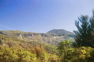
The day dawned fine, crisp and clear, ideal for our
exploration of the Taurewa area of Tongariro Forest. Tongariro Forest is now DOC land, but policy is
that the forest not be developed to the high standard of the adjacent Tongariro National Park with well-maintained
tracks, visitor facilities, etc. but used for such activities as mountainbiking, hunting and outdoor
adventure training with the area being allowed to eventually revert to its original wholly native forest.
The area is in fact a mixture of native forest, scrub and pine forest, and of the many roads and tracks
left as a legacy of logging days (up to the mid-1970s) only a handful, including the Taurewa Loop Track,
42 Traverse, Ohinetonga Track near Owhango, and the short track to Te Porere Redoubt will be maintained.
The Taurewa area of the forest, which we visited, is home to the Sir Edmund Hillary Outdoor Pursuits
Centre and three camps used by school and other groups for outdoor adventure training.
As the
tramp included unmarked tracks and much route-finding and map-and-compass work, we had to be especially
strict about keeping the group together, staying in front of the tail-end charlie and stopping at all
junctions and ambiguous places to group up. The group was very well behaved in abiding by these principles.
We drove to Mangatepopo Camp School, which was originally the Mangatepopo School and is now one of
these three camps, then left cars at tramp’s end, the access to Te Porere Redoubt. At Mangatepopo Camp
School we were met by acting caretaker Jim, and not only did he show us the start of the Taurewa Loop
Track but he led us along the first five minutes of the track till it crossed a forest road.
|
|
 |
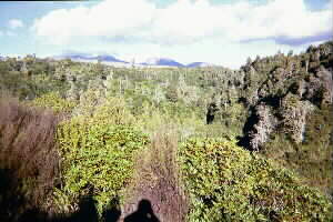
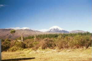
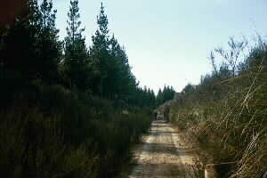
The Taurewa Loop Track at first went through scrub and across a stream, with views of Tongariro and
snow-capped Ngauruhoe, then into podocarp forest as a well-formed track boardwalked in places. After
about an hour we took a side track leading to the Old Tram Route track. This was originally part of
the network of railway lines used in years gone by to bring felled logs out of the bush for processing
at the nearby sawmills. The track was a little more overgrown than the Taurewa Loop Track but was easy
to follow and went through some long cuttings. There was no trace of the original railway tracks.
This track came out to a vehicle track, and we soon came to the second of the three outdoor activity
camps. Like the Mangatepopo Camp School it was unoccupied when we were there, but is well used by school
and other groups during the week. We stopped beside the camp, and while we were sitting down admiring
the fine sunny weather with the forest around us, and Tongariro and Ngauruhoe behind us, Eileen reminded
us that all this was God’s creation, and what He has done both in creation and in our lives. The Bible
describes the heavens, moon and stars as the work of God’s fingers. She then said that God had to give
up his dearest piece of creation - God as Jesus Christ - for our salvation. Did we do anything to deserve
our salvation? No - it is a free gift for the asking.
|
|
 |
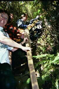
By now it was close to midday, so we had our lunch. Afterwards we took a track across a footbridge
to come to the camp’s outdoor training area, a collection of ropes and structures including a high wall
used for climbing and abseiling practice. It then took a little hunting to get on to the road that eventually
led to the remains of the Ketetahi mill settlement, and we had to ask a local resident for assistance.
The Ketetahi sawmill closed about 1962, and the houses still remain but in a much dilapidated and uninhabitable
condition.
|
|
 |
Just past the ghost town the track seemed to peter out altogether, and Laurie and Terry volunteered
to scout around for any suggestion of the track that would go on to drop down to the Mangatepopo Gorge
near the Tongariro Power Station intakes. Eventually we came on to a track that soon became well defined
as it carried on through bush. After a while we came to a lookout over the Mangatepopo Gorge, with Tongariro
and Ngauruhoe in the distance. From there it was a steady and steep drop to the gorge, with the track
stepped in places. We came out near the end of Access Road #3 and had a rest stop on the mown grass across
the road. We could now see the half moon in the sky, and we were reminded of what Eileen had said earlier
about God’s fingers.
|
|
|
|
We took a track climbing from behind the Outdoor Pursuits Centre climbing practice area in the gorge,
to come out back on Access Road #3 on the plateau. To find the vehicle track leading off that road towards
the Te Porere Redoubt required a map and compass; this was an undulating vehicle track through tussocky
scrub that eventually became a foot track - again we had to use map and compass to ensure we were on
the right way.
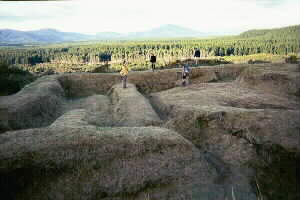
The Te Porere Redoubt was a surprise after a day of route-finding and map-reading.
This was the site of the final major battle of the New Zealand land wars, where the Maori warrior Te
Kooti with his 300 men were defeated by a force of 540 Maoris and Europeans. Te Kooti was shot in the
hand, but escaped into the heart of the King Country to elude capture. The redoubt was well preserved
with its trenches and walls, covered with grass and maintained with weedeaters or similar equipment.
This was actually the first of two redoubts we were to visit; the first one was on a hilltop whilst the
second one was further down towards the carpark. On the second redoubt we were able to walk only in the
trenches; a sign asked not to walk on the tops of the walls.
|
|
 |
It was about 4:45pm when we arrived at the carpark where our cars were waiting. We drove back to
the Lake Taupo Christian Camp, where Christine and Lin cooked up a lovely dinner of pasta and veges.
Afterwards we went into Tokaanu for a welcome soak in the hot pools. Even though the pools were fresh
water heated by the thermal waters from the nearby hot springs, they were nice and hot.
Sunday
Another glorious day - and frost on the roofs of the cars - meant all was on for our tramping in
the Turangi area. We were to have climbed Mt Tihia, Pihanga’s sister mountain, but a quick reccie done
the previous day on the way back from the Tongariro Forest found the track entrance off the Te Ponanga
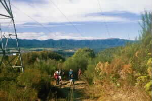
Saddle Road was not easy to find and there was no parking nearby. Instead we tramped the Pylon Track,
a vehicle track that went from a side road off the Te Ponanga Saddle Road along the side of the hills
to come out on SH41 above Waihi.
Again we had to leave cars at both ends of the track, and we
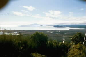
started at the Te Ponanga Saddle end. It was a pleasant vehicle track through bush, with views in places
out to Lake Taupo and surrounding areas. About a third of the way along there had been a bridge that
was washed out many years ago, and the track reduced to a walking track around it. Of the bridge itself
there was no trace other than some wooden planks in the ground, and a sign warning of the danger of the
bridge almost completely covered in gorse and other bush. In several places there were side tracks off
either side, but we had to keep to the main track.
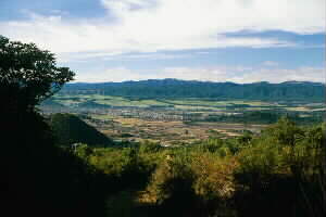
We stopped for morning tea at a high point
about two-thirds along the track. There was a view looking back to Turangi with the prison farms and
Kaimanawa Ranges behind; and ahead to the hills covered with plumes of steam from the Hipaua Thermal
Area. Don gave us a mini-Bible study on a subject dear to him, the mercy of God. God’s heart is a heart
of love and mercy. God is described in the Bible as love (a noun) and holy (an adjective - not the noun
holiness). Don used the story of how while Moses was up on Mt Sinai receiving the Ten Commandments, the
people followed his brother Aaron who made a golden calf as an object of worship and ended up partying
and being naughty (Exodus 32). God told Moses that His anger will blaze out and destroy the people,
but Moses prayed that God would spare them, and He did so. God has to judge, but he would do so in tears.
He is patient and delays judgment (2 Peter). Psalm 103 brings out the compassion of a God who is
slow to anger. God longs for people to come to Him so He can show His love (Isaiah 30:18). Luke 6:35-36
we are commanded to love our enemies, and to show as much compassion as God does. The greatest image
of God’s mercy is Jesus Christ on the cross, sacrificed so that we may have eternal life even though
we don’t deserve it. We finished with a time of prayer and the first verse and chorus of Great Is Thy
Faithfulness.
|
|
|
|
|
|
We dropped down then climbed over another hill and were out on SH41 by about 11:15am. As several
people wanted to go home early, we had no time for a planned one-hour loop on the Tongariro River at
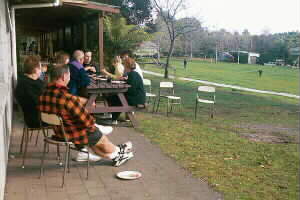
Turangi. We returned to Lake Taupo Christian Camp for lunch, which we had outside on the verandah with
a horde of sparrows gobbling up spare bits of bread thrown out to them. Then out came the wallets to
pay the trip costs, and the hoover to get the place clean, and we were away by 1:30pm for an either pleasant
or boring (or both) trip home along State Highway 27 once more. We were back at The Bracken shortly after
6pm.
|
|
 |
COST: $77 (travel $41-50; food $8; accommodation $27-50). Tokaanu hot pools $2-50.
|
|
|
|
|
|