Twenty-two people turned up to tramp the recently-opened third section of the planned Te Araroa Walkway
that will eventually extend the entire length of New Zealand from North Cape to Bluff, starting at Pakiri
and climbing over Tamahunga to finish on Omaha Valley Road. The first section, between Kerikeri and Waitangi,
opened in 1998, and the second section between Meremere and Rangiriri opened in 2000 and was tramped
by the Club in July last year.
We left The Bracken about 8:15am and travelled to Matakana village
where we met up with some people who had come from the North Shore, Snells Beach and Wellsford. From
there we travelled to Pakiri township, with Trevor’s van being left at Omaha Valley Rd to ferry the drivers
back to collect their cars after the tramp.
It was about 10am when we started out on our tramp
from Pakiri. The start of the walkway was marked by a descriptive Te Araroa sign, but deliberately placed
in front of the sign was a large sign warning people not to enter the private land without written permission.
A phone call to the landowners a few weeks before revealed that the sign was put up by the previous landowners
in disgust at being made bankrupt, and was to be ignored - the walkway was legal public access provided
one stayed to the route and did not stray off onto the adjoining farm land.
|
|
 |
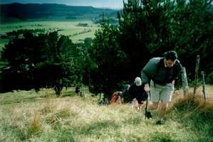
We had an hour of steady climbing, first of through a short patch of pine forest then through open
pasture. As we climbed, a panoramic view out to Pakiri beach with the Whangarei Heads in the hazy distance
unfolded behind us.
|
|
|
|
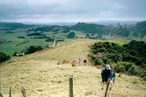
Our morning tea stop was where the track met the paper road extension of Rodney Rd. From there the
track continued along the ridge through more pasture, with extensive views to our right (north) looking
down to Pakiri township and the beach beyond.
|
|
|
|
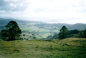
In one or two places we could also look down to the coast at Omaha.
|
|
 |
Ahead of us we could see the twin peaks of Tamahunga. We would be climbing the left-hand peak, but
not the right-hand peak that had the radio transmitter station.
|
|
 |
We carried on into scrub and soon faced a steep muddy descent.
|
|
 |
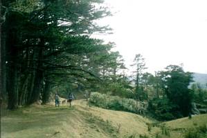
The track carried on, up and down, and left the private property to enter the native bush of Omaha
Forest, now a DOC reserve. Then began the final climb to Tamahunga, a gentle uphill that became steeper,
with a short rocky patch leading to a lookout where we could see down into the head of Omaha Valley with
its quarry.
|
|
 |
Five minutes further on was the summit, one-and-a-half hours from our morning tea stop. We had our
lunch sitting on a wooden helipad in a clearing.
Unfortunately we had no view from the summit.
There was a trig station, but its usefulness had been outdone by all the bush growing around the summit.
Nelson told us what forthcoming trips the Club had to offer, then Barbara said a prayer for Joy,
a faithful Club member who was stricken down with cancer and about to have the tumour removed on the
operating table. John on the spur of the moment decided to phone Joy to say hello from everyone on the
tramp.
|
|
 |
From the summit the track dropped steeply down through bush into Omaha Valley. Near the bottom we
came out onto open farm land once more.
|
|
|
|
We were out by about 2:30pm, and Trevor went around in his van with the drivers to pick up their
cars.
Our mandatory ice cream stop was at the Kowhai Dairy, one of the two main icecreameries
in Warkworth. Then homeward bound having enjoyed another section of what will eventually stretch from
North Cape to Bluff.
COST: $13
|
|