|
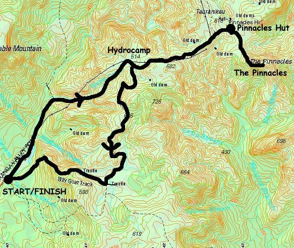
Base map: NZTopoOnline, extracted February 2005, Crown Copyright Reserved
|
Saturday
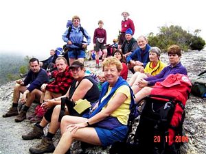
Twenty members departed from Bracken Avenue soon after 7.30am, the earlier departure
intended to give us ample time to climb the Pinnacles later that day. We were soon across to Kopu and
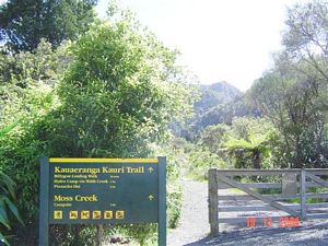
looking out for the right turn, signposted Kauaeranga, by the BP services opposite the ‘Toyota’ factory
at the southern entrance to Thames. 13km up the valley we arrive at the temporary Visitor Centre, temporary
because the actual centre had recently been totally destroyed by fire. Peter and Val went to pay for
our bunks, and after we had used the toilet etc. we continued a further 9km to the road end.
|
|
 |
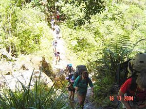
From the roadend we took the track across the river. After 20mins we took the right hand signposted
turn and followed the old packhorse track for 1 - 2 hours. This sometimes steep track to the Hydrocamp
clearing was used by kauri bushmen travelling to logging sites in the upper Kauaeranga during the 1920s.
Just after the first swingbridge we saw steps hewn from solid rock, cut to make the journey easier for
packhorses. We also looked for the original kauri steps beyond the second swingbridge. At the top of
the climb up Webb Creek the remains of a skidded road were visible beside the track. Skidded roads were
made from small logs laid lengthwise with cross pieces forming the ‘skids’. Logs were pulled along the
skids by teams of bullocks or steam haulers.
|
|
|
|
|
 |
In the early 1920s, logs were hauled out of Condemned Creek and along the skidded road, then rolled
into Webb Creek. Condemned Creek was so-called because it was unsuitable for use as a driving creek -
logs were smashed to pieces at the bottom of a high waterfall. To get around this problem, a short canal
was blasted in the saddle between Webb and Condemned Creeks to divert water into Webb Creek. In April
1993, a flash flood caused landslides which wiped out the Webb Creek Dam and diverted all the water back
down its original course. The Hydrocamp, now covered in debris from the flash-flood, was used as a campsite
by workers putting in the ‘hydroline’ (powerlines) to the east coast in the late 1940s. (About 2 hours
from the roadend)
Leaving the Hydrocamp the grade became easier as the track sidled around a hillside
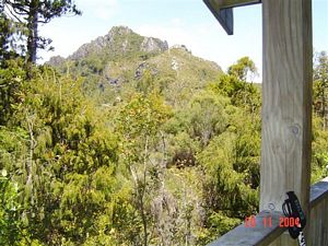
and reached an open ridge alongside the Hydroline. There were spectaculer views down a branch of the
Tairua River to the east and the jagged volcanic landforms of Tauranikau and the Pinnacles ahead. The
hut (completed in 1995) was 10 minutes down a signposted side track. (About a further hour from Hydrocamp)
The remains of the Dancing Camp Dam are at the end of a track 5 minutes below Pinnacles Hut.
The dam, built in 1924 by Jim Angel, was the second largest in the Kauaeranga. It was partially restored
in 1994 using kauri timber washed downriver in the 1993 flash flood. Most of the 100 dams built in the
Kauaeranga have now either collapsed or are in poor condition.
|
|
 |
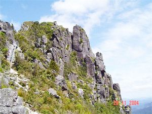
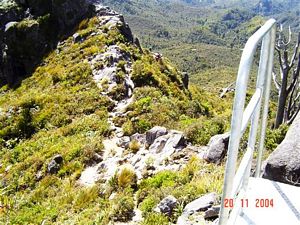
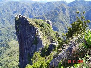
At the hut we claimed our bunks, had a cuppa and those who wished scrambled up to the Pinnacles.
Others visited Dancing Creek Dam and reamined at the hut. The climb (some sections are laddered) which
leads to the summit of the Pinnacles (759 metres) is steep but the reward was spectacular views of the
bush, mountains and coastline of the southern Coromandel. (About 2 hours return) On return to the hut
we washed the mud from our boots, cleaned up, prepared our evening meal and enjoyed a good natter with
our friends. We even had an impromtu bush ball accompanied by Don and Peter on melodica and harmonica.
|
|
|
|
|
|
|
|
Sunday
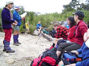
Following breakfast and lunch preparations on Sunday, we ensured that all the
club gear was packed with us before we retraced the track to the Hydrocamp. We paused here for morning
tea and a time for a short reflection led by Peter O. in which he compared carrying a First Aid Kit to
our daily journey with God.
|
|
|
|
|
We then took the Billygoat Track and had a steady 30 minute climb up a former pack track (later
bulldozed when the powerlines were put in) which led to a saddle with excellent views down the Kauaeranga
Valley to the Hauraki Plains. Some original forest was seen on the ridge above the saddle. A little further
on, a knoll overlooks the Billygoat Basin. The first attempt to log the Billygoat Basin was in the 1880s.
Three dams, a tramline and a chute were built, but driving logs down the destructive Billygoat Falls
proved too wasteful and after a number of years the task was abandoned. In 1888 a bushman known as Racecourse
Jack was sacked from a logging gang. In retaliation, he set fire to the cutover bush causing a huge fire
which destroyed a large area of forest and the basin’s three dams. Renewed attempts were made to log
the Billygoat Basin in the 1920s. A steam hauler pulled logs from the bush to a camp; a converted farm
tractor then pulled logs along a tramline to another steam hauler at the top of the Billygoat Incline.
|
|
 |
We dropped down into Billygoat Basin and crossed Billygoat Stream before passing through a clearing
with basic camping facilities. Five minutes on, a 50 metre side track gave us a view of the Long Trestle.
Timber trestle bridges, made of kauri, were used extensively on bush tramlines. The Long Trestle was
160 metres long and 11 metres above the ground at its highest point. It was blown up for safety reasons,
as part of an army exercise in the 1960s.
Back on the main track, we passed the Tarawaere Track
junction and Hihi Route (tramped by five members in October 2003) before going through deep cuttings
blasted in rock for the Billygoat Tramline. We looked for kauri sleepers along the cuttings and the remains
of two short trestle bridges beside the track. Near the hauler site, at the top of the incline, there
were good views of Billygoat Falls (180 metres). We also saw some intrepid folk enjoying the abseil down
the falls although it seemed to us from our lofty and distant viewpoint that they would get very wet
at the base of the falls. The track sidled around a ridge before dropping down to a crossing over the
Kauaeranga River. We used the wire swingbridge although it really is provided for use in flood. The Kauaeranga
Road was about a further half hour from the hauler site. {with acknowledgements to the DOC leaflet for
historical detail in this report}
Returning to our vehicles, we loaded the packs and club gear
and headed for ‘home’ Bracken Avenue. Fine weather on Saturday and the rain kept away until we reached
our vehicles on Sunday.
All in all this was again an excellent last moment opportunity to check
out gear before the extended summer tramps in South Island.
COST: $40 ($18 travel; $22 food and
accommodation)
|
|
|