A fine day after many days of wind and showers brought out 35 people to a perennial Club favourite,
the Mt William Walkway in the Bombay Hills. On past occasions the Club would walk the entire track, starting
at Puketutu Rd and finishing at Irish Rd off SH2, but as it was mid-winter with the shortest day just
one week away and sunset was at 5:11pm, we decided to start and finish at Puketutu Rd and climb both
summits on the walkway.
We left The Bracken about 1:45pm and met up with some more people at
the end of Puketutu Rd., Bombay, the start of the Mt William Walkway. We were on our walk by 2:30pm.
|
|
 |
The whole walk was through open farm land, and after about ten minutes we took a side track that
climbed up to Puketutu summit. Once there we passed a radio transmitter station and came to the trig.
|
|
 |
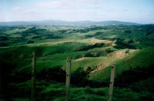
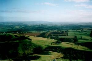
Puketutu is the highest point on the Bombay hills at 376m asl. We had a good view out towards the
Hunua Ranges, and southwards to the north Waikato basin. We could also see out towards Auckland but it
was hazy and we would be looking into the sun. Binoculars were need to make out the outline of Auckland’s
extinct volcanoes and the Sky Tower.
|
|
|
|
|
From there we went back to the main track and carried on to Mt William, the second highest point
in the Bombays, just three metres shorter at 373m asl.
|
|
 |
A lone tramper coming the opposite direction thought we were cattle spread out in the distance until
he came closer to us.
|
|
 |
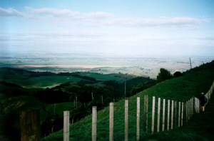
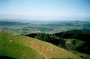
It was a steep climb to the summit of Mt William, but rewarded by panoramic views of the north Waikato
and the Franklin district. A well deserved rest stop, although one or two not-so-fit people stayed at
the bottom.
|
|
 |
|
|
|
From there we returned to the carpark, and were out soon after 4:30pm, having enjoyed a pleasant
winter afternoon away from the city.
COST: $6
|
|
|