The Club has been to Rangitoto many times over the years as a day trip, but this may be the first time
Rangitoto has been done as a weekender with its neighbour Motutapu Island. Eleven people enjoyed a very
hot but lovely weekend, and two more enjoyed our fellowship with a day visit to Rangitoto. Thanks to
DOC closing the Home Bay wharf on Motutapu Island as part of a tightening up on safety following the
fatal Cave Creek disaster in 1996 we had to carry our packs instead of being able to go straight to Home
Bay and set up camp first. The climb up Rangitoto was a real grunt in the hot weather, but on the Sunday
those who wanted to could have some of their luggage taken by truck to Islington Bay. The beaches were
really nice and refreshing!
Saturday
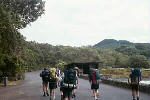
We went to Rangitoto Island on the 9:30am Fullers
ferry, one of their modern “cat” boats, and on arrival at the island had a browse at the information
board and did any last-minute drink purchases at the tiny shop there. There was a public phone there
- not a modern card phone but an old-fashioned phone where you had to turn a dial around instead of press
buttons to ring someone. I’m sure none of our group had seen these phones for years! And it still worked
- there was no charge.
|
|
 |
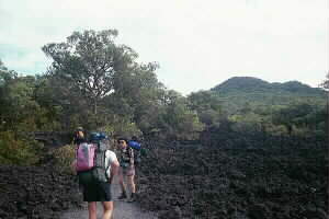
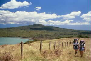
It was hard yakker climbing to the summit of Rangitoto on a hot sunny day with full packs. The glade
at the turnoff to the lava caves track was a welcome rest before the final grunt to the top. The 360
degree panorama of Auckland and the Hauraki Gulf was fantastic, with fine and sunny weather just like
our last day trip there back in September 1998 but much hotter. But this time there was added interest
- all the boaties setting out northwards in the hope of getting a view of the first of the Americas Cup
series of races between the Italian yacht Prada and our Team New Zealand (TNZ). One keen Russell
Coutts hero-worshipper was perched atop the old wartime lookout building with a telescope set up ready
for the action.
|
|
|
|
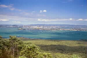
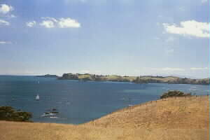
We carried on down the long boardwalk built several years ago for the Fullers Volcanic Explorer
guided tours to the Summit Road. From this walkway there were fantastic views of Motutapu Island and
the gulf beyond as far as Moehau and the Coromandel Ranges. We then followed the road all the way to
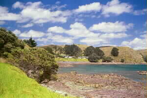
Islington Bay, a gradual downhill then level travelling. Rangitoto’s unusual terrain of trees growing
out of jagged lava rock, with numerous large bare patches, was a special feature of this stretch. There
is no other place like this anywhere in New Zealand; the island is an extinct volcano believed to have
erupted about 800 years ago.
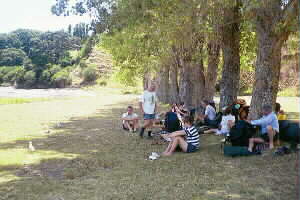
A line of trees on the flat grassed area just north of the road
at the start of Motutapu made a welcome shady spot for lunch after the hot journey down the mountain.
Unfortunately the tide was out so a swim was out of the question. The two day trippers left us afterwards
to return to Rangitoto Wharf.
|
|
 |
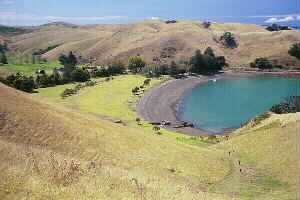
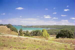
We set off on the Motutapu Farm Walkway, a two hour route over open farmland to Home Bay. The track
followed the clifftops a short way before turning inland to climb very gradually up to the Motutapu trig.
Like Rangitoto there was a view all around, but much different - Motutapu is not nearly as high as Rangitoto.
To the northeast we could see Rakino Island, with Moehau and Great Barrier Island in the distance. And
of course there was the East Auckland coastline and Motuihe, Waiheke, McCallums and Ponui Islands. From
there it was a very gradual downhill with a final more steep descent to our campground at Home Bay. It
was about 3pm when we put our packs down, put on our togs and cooled off in the water - Home Bay is
swimmable at any tide.
|
|
 |
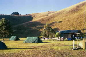
The tents went up - we used two fairly new tent fly sets of the same design as the old blue or brown
tents we had used in the past, but the two flies in each set were joined together with velcro strips
to form a large tent with three poles standing about 1.7m high. This particular design of tent has the
advantages of being light weight and being able to sleep quite a number of people; trampers provide their
own groundsheets in place of a sewn-in tent floor.
The rest of the afternoon was taken up in siestaing
and/or doing short walks, including a walk up the hills overlooking the far end of Home Bay. As we looked
out across the eastern Hauraki Gulf we saw hordes of boats travelling southwards. As we found out later,
there was not enough wind to run the yacht race and all the spectators were heading homeward. I’m sure
the fellow atop Rangitoto with the telescope was disappointed with paying the $20 boat fare, the brisk
climb up the mountain and hours waiting patiently, all for nothing! Perhaps not - maybe he wasn’t a fair-weather
spectator?
|
|
 |
Eleven hungry tummies were treated to pasta and vegies followed by apricots and custard about 6:30pm,
and a special occasion was marked - David’s birthday, complete with cake and candles. Afterwards the
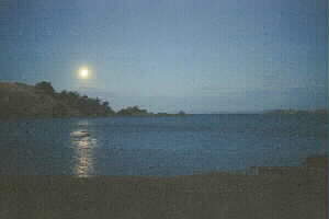
siestaing and walks continued into the twilight. It was lovely to see the full moon rise over the far
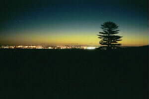
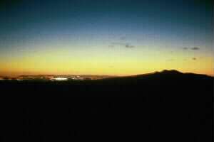
headland. John did a walk back in the approaching darkness to the Motutapu Trig to see the lights of
Auckland in the distance with the lovely last yellow tinge of twilight silhouetted by the summit of Rangitoto
Island and the distant Waitakere Ranges. It was lovely returning in the moonlight across the paddocks
without needing a torch, with the lights of boats and distant shore settlements below. Just as he finished,
he broke part of a shoe and woke a herd of cattle sleeping nearby!
|
|
 |
|
|
Sunday
We rose to another glorious day, and some of us chose to get fully awake with a swim.
We had Goldilocks Special, a favourite breakfast dish with most tramping clubs, before we packed up
and broke camp.
|
|
 |
Before we set off on our tramp across Motutapu Island, Marian told us about fair-weather tramping,
ie. making up excuses not to go on a tramp such as too hard, a little bit wet, etc. A serious tramper
would ignore such excuses and go ahead - he/she can not determine the weather or conditions. (that does
NOT mean that we should go tramping against the advice of rangers or authorities warning it is too dangerous
to do so). If the weather is bad we should not grin and bear it, but enjoy ourselves regardless! She
spoke of the recent Heaphy Track tramp she was on where there was quite a bit of rain - but everyone
had a good time with the scenery in a different “light” and the fun of such things as the new millennium’s
eve concert. The Tongariro Crossing tramp she led a few weeks ago was full of mist and cloud, but on
arrival at Ketetahi Hut the weather cleared to give a grand view of Lake Roroaira below. David commented
that when tramping just after a spell of rain there is a special freshness as if the rain had “washed”
nature. Marion then compared this to our lives in general, asking Can we find good in every situation?
(refer Romans 8:28). Our lives are always being made richer by our difficult situations. 1 Thessalonians
5:16 commands us to be joyful always, keep on praying and be thankful in all situations because it is
God’s will to do so. David then said we can look back over our experiences to see God work everything
out, but we can not look forwards. Nelson mentioned that Motutapu had been spoilt by the Maoris and Europeans
over the decades, and DOC is in the process of restoring the island to its original bushclad condition,
then recalled a devotion time on the St James Walkway where a challenge was shared - for every observation
of nature, can you give it a practical spiritual meaning? We concluded our time with singing For the
beauty of the earth, a hymn about God’s gifts to us in the beauty of nature, our senses to perceive
them, and fellowship with relatives and friends. This hymn was sung at the recent funeral of Keith Hitching.
|
|
The road from Home Bay going northwards was a gentle but steady uphill. To our left there was a gully
where native trees have been planted as part of DOC’s programme to reforest the almost treeless island.
At the top we left the road and followed a very broad ridgeline past a number of old concrete buildings
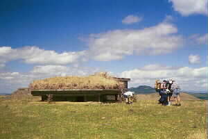
that had been built for defence against a possible Japanese invasion during World War II. Further along,
after a gradual downhill, we left our packs and walked out to Billy Goat Point, the northern most tip
of Motutapu. We could look out and see hordes of boats returning in the hope the yachts would race this
time. There was also an excellent view of Rakino Island.
|
|
|
|
We returned and collected our packs and dropped down to Sandy Bay and cool off in this all-tide beach.
Only five minutes further on was Administration Bay with the old army barracks dating back to wartime
when the island was closed off as a military area. For many years this was used by the YMCA as a youth
camp, and now continues the same role as an outdoor education centre. We had lunch under the pohutukawa
trees on the sandy beach - and this time the yachts were racing! We could clearly pick out the two large
masts and sails of Prada and TNZ as they sailed leftwards then rightwards.
|
|
 |
Our final leg was along the rocks to the next bay westwards, then in and over the hills along the
walkway from the camp to Islington Bay. Once onto the hills Rangitoto came back into view, the track
continued an undulating course passing numerous old wartime bunkers set into the ground. A cow that had
just arrived at the pearly gates was not a pretty sight but that was soon forgotten as we carried on
enjoying the beauty of the azure sea against the dark green of Rangitoto Island in the distance ahead.
We arrived at Islington Bay about 3:30pm, and enjoyed a siesta in the previous day’s lunch spot before
carrying on to the wharf to wait for the 4:30pm boat.
|
|
 |
This time we had the Koru, an older Fullers boat that was originally the flagship of Blue Boats
with an open upstairs deck. We had to share it with a large group of North Shore Tramping Club members
coming home from a day trip, and only ten people were allowed upstairs. As the boat pulled into Devonport
we had a closeup view of the Bark Endeavour tied up there. This was an exact replica of the sailing
ship Captain Cook used to explore and chart New Zealand’s coastline a few hundred years ago, and was
in Auckland as part of its “floating museum” tour of New Zealand. An even greater highlight of our journey
was to see both our new Anzac frigates Te Mana and Te Kaha tied up at the Devonport naval base. It
was a thrill to be able to see and photograph these two warships which we, along with all other New Zealand
taxpayers, have paid for and are proud to own! We were
back in Auckland just before 6pm.
And
as we made our way to our cars or buses home we could see five planes overhead writing in the sky Well
done, TNZ!
COST: $30 (boat travel, food, campground)
|
|
|
|