The tramp across the Hunua Ranges between the top of Ness Valley in the north and Mangatawhiri Dam in
the south would make a fairly easy Saturday day trip. However, as the northern section of this was in
private commercial pine forest and the forest owner Waytemore had its harvesting gangs working Mondays
to Saturdays, we could get permission to do this tramp on a Sunday only. To be able to do this as a Sunday
afternoon/evening tramp we had to take advantage of the extra daylight available in the summer months
such as December. Twenty-five people turned up for this special Sunday trip, and because of the large
road distance between the two ends of the tramp we had to split up into two groups going in opposite
directions and swapping car keys halfway.
We left The Bracken at 1:30pm and met up with people
from Howick and Pakuranga at the Woolshed in Clevedon at 2pm to finalise car loads for the two options.
This took a while, then there was a further hiccup with one of the cars not starting - apparently this
was a high-tech car that for security reasons would not start just by putting the keys in and turning
the ignition on. After trying to find the magical button or “key” to getting it to go, and asking a couple
of local people, one of us phoned another Club member who had driven that car on the Easter trip to the
Kawekas, and we were told simply to press two of the car’s pedals and lo and behold it started right
away!
Thus is was not till almost 4pm by the time the two groups started on their tramps - John
led a group of 13 from the top of Ness Valley, which had more downhill, and Geoff took a group of 12
the other way from Mangatawhiri Dam with the long grunt from the reservoir to the ridgetops.
The
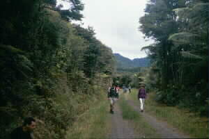
first part of the tramp from the top of Ness Valley (the end of Moumoukai Hill Rd) was in native bush.
The track was well defined, but there were a few obstacles such as fallen trees. After about half an
hour we came to a lookout with a view out to the Umupuia Peninsula (Duder Regional Park) with Waiheke
and Ponui Islands behind, and the Mataitai Forest, visited by the Club just six weeks before on a cold
wet Saturday, closer to the foreground. We then carried on, but became a bit apprehensive when after
a further half-hour the track did not appear to come out onto a road as shown on the map - what the map
showed as the track following this section of Plows Rd was actually the track following about 20m alongside
the road. So we decided to bushbash to the road as we had lost quite a bit of time already back in Clevedon
with trying to get one of the cars to go. We found that the track would have come out onto the road just
a couple of hundred metres further on!
|
|
Further on we came to the start of St Pauls Rd - this was not signposted as such, the only signposts
being for the Kohukohunui Track. We were able to identify this junction only with a map and compass.
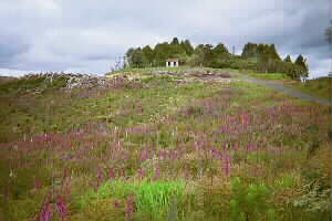
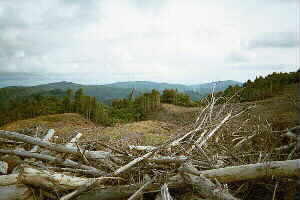
St Pauls Rd dropped down into a gully to come up the other side - the terrain was pine forest with most
of it recently clear-felled giving views of the surrounding countryside. The map and compass came in
useful again to find our track amongst the maze of side-tracks at the bottom of the valley.
|
|
 |
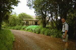
Near the top of the long uphill on the other side of the St Pauls Rd gully we passed a dilapidated
old house marked as a historic site - this probably was originally a farmhouse going back to the days
when a large part of the Hunua Ranges was cleared as farm land. As we approached the end of St Pauls
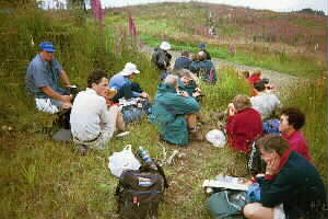
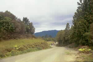
Rd, we saw the other group coming, and it was just after 6pm as both groups met up at the junction of
St Pauls Rd with Keeney Rd for our dinnertime “lunch” break and swapping of car keys and experiences.
|
|
|
|
|
|
We lingered only about twenty minutes then we were off again. To save time the other group, who had
come up from Mangatawhiri Dam, decided not to do St Pauls Rd but to carry along Keeney Rd through to
the Moumoukai Hill Rd carpark, and were out by 7:30pm.
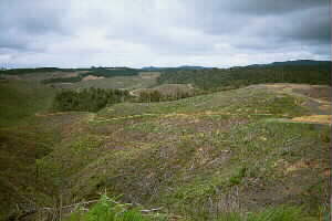
Keeney Rd continued southwards towards
Mangatawhiri Reservoir undulating through a mixture of forest and recently-harvested land. In one place
what looked like the main track going up a mound was actually just a side road to a service area that
served as a lookout over the surrounding ranges. We then got back onto the main road to begin the long
steady descent to follow the Mangatawhiri Reservoir, the first glimpse of its waters being had not too
much further on. We were now travelling through more mature pine forest, giving way in due course to
native forest - a very pleasant walk in the early evening.
|
|
|
|
We passed the start of Ernies Track before carrying on downhill to follow the lake edge - but not
closely to the edge, we only had glimpses of the reservoir rather than a continuous view. It was about
8:30pm when we were finally out at Mangatawhiri Dam, with the first people able to get their cars and
drive back up through the gates, that were supposed to have been locked at 4pm, to pick up the stragglers.
|
|
|
|
It was dark when we all rendezvoused back at the Clevedon Woolshed so that people could get back
into other cars for the return journey to The Bracken or homes in the Howick area. Everyone was tired
after a very enjoyable day.
COST: $7 ($4 The Bracken-Clevedon; $3 Clevedon-Hunua Ranges)
|
|
|
|
|