This was a trip with a difference - an opportunity to get familiarised with an important aspect of tramping,
how to use a compass and get bearings for cross-country travel. Nineteen people had a fun time doing
several exercises to learn these skills then have a go at Auckland’s only permanent orienteering course,
the Karamatura Valley at Huia.
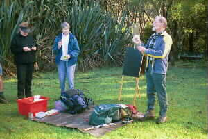
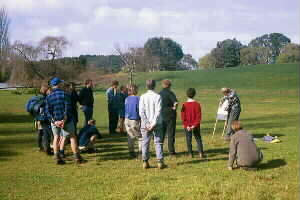
We started our day with a brief talk from our instructors Peter
and Val, who told us how to use a compass to gain a bearing - by setting the pointer to north then reading
the degrees on the circle of the compass to get the direction. They explained that a good compass was
usually set on a piece of clear plastic that had lines to align the map, one or more rulers used in conjunction
with the map’s scale to determine distance, and a magnifying glass to make it easier to read small symbols
on the map. Some more fancy compasses had right angles marked to help in finding a grid reference.
|
|
 |
Our instructors got us to walk between two markers exactly 50 metres apart on flat ground so that
we could count how many footsteps at normal walking pace it would take to cover the distance. Then we
walked the same distance uphill, then downhill, to see what difference would be made to the number of
footsteps, eg. one person walked the 50 metres in 65 paces on the flat, then 68 paces uphill and 63 paces
downhill.
Our next exercise was to walk the triangle, ie. 10 paces at 120ş, then 10 paces at
240ş and finally 10 paces at 360ş. This if done correctly would finish back at the starting point - we
were given numbered blue plastic milk bottle tops to put on the ground to mark this.
Once this
was done we broke up into pairs to do a course that consisted of about eight sets of distances and bearings,
using small numbered metal markers that had been set into the ground. The distances were in metres, so
we had to judge the number of paces required to measure these.
|
|
 |
After a morning tea break we were back in our pairs for our blindfold exercise. One person in each
pair would set a bearing, then be blindfolded and walk about twenty metres, with the other person seeing
whether the blindfold walk was straight on course or wander off to one side. The two persons in each
pair would then swap roles. Such a situation in reality would be quite rare, such as a pitch dark night
with no lights visible.
Another situation that is more common is fog or mist, where one can see
the ground but nothing ahead. We repeated this exercise this time with a large paper bag over the head
to prevent being able to see ahead but be able to see the ground. The person with the bag over the head
would set the bearing, then be able to keep looking at the compass to ensure keeping in the right direction.
Peter and Val then told us about using a back bearing to ensure we keep on the right course. When
one follows a compass bearing, eg. 150m at 160ş, quite often he/she would finish slightly off-course.
To check this, one would then look back to the starting point, line up the compass and move till that
point is at 180ş plus the original bearing, ie. 340ş in this example. Doing this would ensure being back
on course. We then had a practice on a course with several such bearings - we would do the first bearing,
and when we found the correct spot there would be the next bearing to follow.
Once this was done
we grouped around the blackboard once more to be told the aim and attack technique. Using an example
of trying to locate a hut beside a bridge across a stream, one would take a bearing on the stream rather
than the hut. Following this bearing one would certainly reach the stream, that would be much easier
to find, instead of going straight for the hut and missing it. Once at the stream, it would be simply
following upstream or downstream to locate the bridge, then find the hut. Peter and Val also explained
there were three norths - true north being the actual axis of rotation of the earth, grid north being
the north-south lines on a map, and magnetic north being the axis of the earth’s magnetic field and approx.
18ş east of grid north (increasing very slightly from year to year). Why the magnetic north moves in
this manner is not completely known - God must have made it that way for a purpose. Peter and Val then
told us that when using a map we would need to take that 18ş variation into account when setting the
map with the compass.
|
|
 |
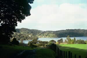
The formal training finished at 1pm, and we sat down for lunch at a couple of picnic tables on the
foreshore of Huia Bay. Afterwards we were given the choice of three set orienteering courses in the Karamatura
Valley, using a map that had been prepared by the North West Orienteering Club for the Hillary Commission
and Auckland Regional Council. These ranged from an easy course of eight control points in the lower
part of the valley through a medium course of eleven points to a long course of fourteen covering the
entire farmed area across the Karamatura Stream.
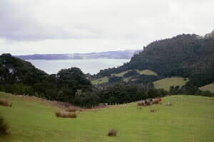
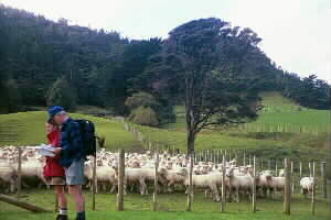
John, Phillip, David and Fredi chose the long
course, which took about 90 minutes, and were treated to a good walk over the Karamatura Valley sheep
farm with great views down to the Manukau Harbour and up to the rugged ridgetops of the Waitakere Ranges.
The others opted for the short course plus a walk up the valley to view a waterfall, except Peter and
Val who “held the fort” to ensure everyone had completed the course and not go missing.
|
|
 |
|
|
We capped off our day of “school” with the mandatory icecream stop at the Huia Store. Our new-gained
knowledge would build up confidence and reduce nervousness and apprehension in people going on tramps
where the tracks are not clearly signposted, and a large amount of route-finding and map-and-compass
work is involved. It would therefore be an excellent idea for this club, and other tramping and outdoor
clubs, to run this sort of activity on a regular (once or twice yearly) basis.
COST: travel $4;
orienteering map $1.
|
|
|